then it’s the territory of what remains of Palestine since Jordan and Israel declared their Sovereign Independence from Palestine in 1946 & 1948. Neither are a part of Palestine, nor is it a part of Lebanon, Syria, Jordan, Egypt or Israel
ShortLink http://wp.me/pDB7k-tM
Plan Dalet was instigated in the months prior to Declaration, exacerbating and escalating the existing civil war. By 15h May 1948 Jewish forces were already outside of the territories allocated for a Jewish State under UNGA res 181 and which the Jewish Agency had accepted as “binding”. The moment Israel was declared an independent state, what had been a civil war in Palestine, became a war waged by the self declared Independent Sovereign State of Israel on what remained of the non-self-governing territory that remained of Palestine.
The basis of Israel’s recognition by the majority of the International Community of Nations/States (over riding the Arab states legal objections), is the : Letter from the Agent of the Provisional Government of Israel to the President of the United States, May 15, 1948 “MY DEAR MR. PRESIDENT: I have the honor to notify you that the state of Israel has been proclaimed as an independent republic within frontiers approved by the General Assembly of the United Nations in its Resolution of November 29, 1947, and that a provisional government has been charged to assume the rights and duties of government for preserving law and order within the boundaries of Israel, for defending the state against external aggression, and for discharging the obligations of Israel to the other nations of the world in accordance with international law. The Act of Independence will become effective at one minute after six o’clock on the evening of 14 May 1948, Washington time.” Also The US acknowledgement has ‘Jewish State’ crossed out and replaced with the “State of Israel”.
The US recognized Israel, 11 minutes after it was declared. “…. within frontiers approved by the General Assembly of the United Nations in its Resolution of November 29, 1947” . The recognition of the limits of Israel’s sovereign extent, echoed by the British after an Israeli Government was elected to the State of Israel and confirmed by the Provisional Israeli Government on May 22nd 1948 at the same time acknowledging Palestine as a separate entity to Israel, has been the basis of the UN and UNSC resolutions for Israel’s actions in “territories, outside the State of Israel” . Actions that have been contrary to the Laws, the UN Charter, the Conventions Israel has ratified and the Chapter VI resolutions the UNSC has passed against Israel’s actions outside of its sovereign extent.
The US veto in the UNSC on Chapt VII resolutions which would find Israel facing the consequences of its illegal actions, is irreconcilable with the official US recognition of Israel on May 15th 1948 and Israel’s illegal territorial acquisitions since being recognized.
By Israel being declared an Independent State, the territories that remained of Palestine, now bounded by the new State of Israel and the four surrounding Arab States were by default, A) not Israeli and; B) independent of Israel.
Israel has never legally annexed ANY territories! Not the “territories occupied” during the ’67 war, OR the territories ‘acquired’ by war by the time the Armistice Agreements were signed in 1949, when Israel was a UN Member state, bound to the Charter in its entirety
Before Israel was admitted to the UN, it was already by International Law inadmissible to ‘acquired’ territory by war. Any war. The law does not differentiate between defensive, aggressive, legal illegal or preemptive war. (see difference between ‘acquire’ and ‘restore’ according to the oft quoted (Professor) Stephen M. Schwebel .
Even territory captured in war must be legally annexed through a referendum of the citizens of the territory to be annexed, sans the citizens of the state wishing to annex. (see the legal annexation of Texas by the USA) So too the annexation of Alaska and Hawaii, both by the same legal process. By which the US itself was instrumental in the legal custom of annexation passing into the Customary International Law and on which UNSC res 252 and its eight reminders are based. It was also instrumental in forming the basis of self determination.
The legal precedent being set by the US itself, is rather irreconcilable with the US veto vote on Chapter VII resolutions in the UNSC, especially as the US recognized Israel as the Israeli Government pleaded to be recognized!
Maps (ShortLink to these maps http://wp.me/pDB7k-tM#maps )
DETAILED Partition Overlay Map (dotted blue lines) for Google Earth
Including the detailed text of the recommended boundaries Israel declared and were acknowledged by the majority of the International Community of nations.
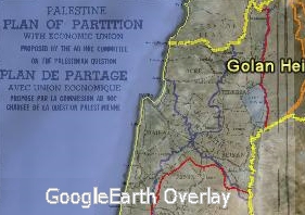
How to adjust the transparency of the overlay in Google Earth
 Enlarge – used in the overlay |
Link to here Exactly WHO is being wiped off the map?  (rough representation only) |
|
LinkTo this section http://wp.me/pDB7k-tM#isdud-vs-ashdod
The Isdud of Palestine 1948 is not the Ashdod of Israel 2010 The Isdud referenced in the 1948 /50 war – 31°45’11.38″N 34°39’47.21″E “From the southern point of intersection the boundary lines run north-westwards between the villages of Gan Yavne and Barqa to the sea at a point half way between Nabi Yunis and Minat El-Qila, and south-eastwards to a point west of Qastina, whence it turns in a south-westerly direction, passing to the east of the built-up areas of Es Sawafir Esh Sharqiya and ‘Ibdis.” |

(ShortLink to non-annexed territories http://wp.me/pDB7k-tM#nonannexed-territories )
Israel has never legally annexed these territories to it’s sovereignty! Neither the British, the US or Russia acknowledged them as Israeli

Bee’er Sheba (Sheva)
(ShortLink to this map http://wp.me/pDB7k-tM#beersheba )

